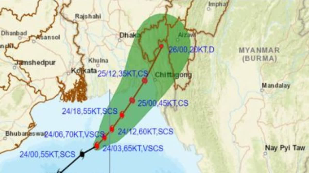
Hyderabad: In a concerning weather update, Cyclone 'Hamoon' has rapidly intensified into a severe cyclonic storm over the northwest Bay of Bengal, prompting the India Meteorological Department (IMD) to issue a series of warnings and alerts. As the cyclone gathers strength, it is projected to continue its north-north-eastward trajectory, with an expected landfall in Bangladesh between Khepupara and Chittagong on Wednesday, October 25, around noon.
The impending cyclonic threat has put seven Indian states, including Odisha, West Bengal, Manipur, Tripura, Mizoram, Assam, and Meghalaya, on high alert, while fishermen have been strongly advised to avoid venturing into the Bay of Bengal until the danger subsides.
The IMD, in its latest report, confirmed that Cyclone 'Hamoon' underwent a significant intensification at around 6 am on the mentioned day, evolving into a severe cyclonic storm. The weather agency took to its official Twitter handle to disseminate this crucial information, stating, "Cyclonic Storm 'Hamoon' intensified into a severe cyclonic storm over northwest Bay of Bengal."
-
SCS Hamoon intensified into VSCS about 290 km east of Paradip (Odisha), 270 km southeast of Digha (West Bengal), 230 km south-southwest of Khepupara (Bangladesh). Likely to weaken and cross Bangladesh's coast between Khepupara and Chittagong around the evening of 25th Oct as CS. pic.twitter.com/6moaRNxqwZ
— India Meteorological Department (@Indiametdept) October 24, 2023 " class="align-text-top noRightClick twitterSection" data="
">SCS Hamoon intensified into VSCS about 290 km east of Paradip (Odisha), 270 km southeast of Digha (West Bengal), 230 km south-southwest of Khepupara (Bangladesh). Likely to weaken and cross Bangladesh's coast between Khepupara and Chittagong around the evening of 25th Oct as CS. pic.twitter.com/6moaRNxqwZ
— India Meteorological Department (@Indiametdept) October 24, 2023SCS Hamoon intensified into VSCS about 290 km east of Paradip (Odisha), 270 km southeast of Digha (West Bengal), 230 km south-southwest of Khepupara (Bangladesh). Likely to weaken and cross Bangladesh's coast between Khepupara and Chittagong around the evening of 25th Oct as CS. pic.twitter.com/6moaRNxqwZ
— India Meteorological Department (@Indiametdept) October 24, 2023
As of 3 am, Cyclone 'Hamoon' had maintained a north-north-eastward trajectory, moving at a speed of 18 kilometres per hour. The storm's centre was positioned over the northwest and adjoining west-central Bay of Bengal, approximately 200 kilometres southeast of Paradip in Odisha and 290 kilometres south-southeast of Digha in West Bengal. This ominous progression called for immediate attention and action by the concerned authorities.
The IMD's forecast has triggered a series of pre-emptive measures. Rainfall alerts have been issued for Manipur, Mizoram, south Assam, and Meghalaya for both today and tomorrow, along with additional warnings for Odisha and West Bengal for today. Furthermore, the Met Department has issued an advisory to fishermen, urging them to stay ashore and avoid the east-central, west-central, north, and the coastal areas off Odisha, West Bengal, Bangladesh, and north Myanmar coasts until October 25.
-
SCS Hamoon over Northwest BoB moved northeastwards with a speed of 21 kmph & lay centered at 0530 hrs IST, 24 Oct over the same region, about 230 km east-southeast of Paradip(Odisha), 240 km south-southeast of Digha (West Bengal), 280 km south-southwest of Khepupara (Bangladesh). pic.twitter.com/G2pOC9Hune
— India Meteorological Department (@Indiametdept) October 24, 2023 " class="align-text-top noRightClick twitterSection" data="
">SCS Hamoon over Northwest BoB moved northeastwards with a speed of 21 kmph & lay centered at 0530 hrs IST, 24 Oct over the same region, about 230 km east-southeast of Paradip(Odisha), 240 km south-southeast of Digha (West Bengal), 280 km south-southwest of Khepupara (Bangladesh). pic.twitter.com/G2pOC9Hune
— India Meteorological Department (@Indiametdept) October 24, 2023SCS Hamoon over Northwest BoB moved northeastwards with a speed of 21 kmph & lay centered at 0530 hrs IST, 24 Oct over the same region, about 230 km east-southeast of Paradip(Odisha), 240 km south-southeast of Digha (West Bengal), 280 km south-southwest of Khepupara (Bangladesh). pic.twitter.com/G2pOC9Hune
— India Meteorological Department (@Indiametdept) October 24, 2023
In a related development, Cyclone 'Tej,' which initially formed over the Arabian Sea and later intensified into an extremely severe cyclonic storm, has made its impact felt. According to the IMD, 'Tej' has crossed the coast of Yemen and has subsequently weakened into a severe cyclonic storm along the coastal region of Yemen. The IMD's latest update suggests that the cyclone is likely to continue its north-westward trajectory and further weaken into a cyclonic storm over the next six hours.
-
Very likely to intensify further into a VSCS for a few hrs during next 6 hours. Thereafter, likely to weaken gradually while moving northeastwards and cross Bangladesh coast between Khepupara & Chittagong around evening of 25Oct as a cyclonic storm with wind speed of 65-75 kmph. pic.twitter.com/awUdGfYkKo
— India Meteorological Department (@Indiametdept) October 24, 2023 " class="align-text-top noRightClick twitterSection" data="
">Very likely to intensify further into a VSCS for a few hrs during next 6 hours. Thereafter, likely to weaken gradually while moving northeastwards and cross Bangladesh coast between Khepupara & Chittagong around evening of 25Oct as a cyclonic storm with wind speed of 65-75 kmph. pic.twitter.com/awUdGfYkKo
— India Meteorological Department (@Indiametdept) October 24, 2023Very likely to intensify further into a VSCS for a few hrs during next 6 hours. Thereafter, likely to weaken gradually while moving northeastwards and cross Bangladesh coast between Khepupara & Chittagong around evening of 25Oct as a cyclonic storm with wind speed of 65-75 kmph. pic.twitter.com/awUdGfYkKo
— India Meteorological Department (@Indiametdept) October 24, 2023
Also read: Cyclone 'Hamoon' intensifying rapidly; IMD issues heavy rain alert in North Eastern states
These developments underscore the urgency of preparedness and timely action to mitigate the potential impact of Cyclone 'Hamoon' in the Bay of Bengal and the continuing vigilance required for 'Tej' over the Arabian Sea. It is crucial for residents and authorities in the affected regions to remain attentive to further updates and heed the warnings from meteorological agencies to ensure the safety and well-being of all communities involved.


